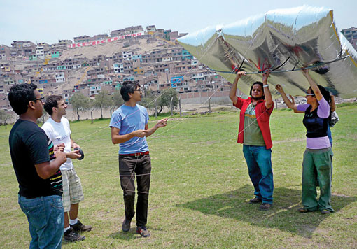
The advent of Google Maps, Google Earth and other easily accessible satellite imaging technology would seem to have made most forms of personal, small-scale cartography obsolete. But outside high-density population centers, many of the images these services provide are often out of date or nonexistent. This is especially a problem in Latin America, where unmapped informal communities spread out from the edges of cites for miles—making it difficult for residents to receive land titles and, by extension, adequate public services.
The Public Laboratory for Open Technology and Science (PLOTS)—an open-source, grassroots data-gathering and research initiative—is now putting these communities on the map. Founded in 2010, PLOTS grew out of Grassroots Mapping, a project developed by Jeffrey Warren, then a graduate student at the Massachusetts Institute of Technology (MIT). Warren was invited by Peruvian NGOs Escuelab and Shuawa Arts Organization to Cantagallo, an informal shantytown built over a landfill in Lima. The community was inhabited by 100 Shipibo Indigenous families who had been unable to win title to the land due to lack of evidence supporting their claims of residency. With Warren’s instruction, Cantagallo’s residents attached a camera with continuous-mode shooting to a helium balloon to take the first clear overhead photos of the entire settlement and delineate its borders.
Though Cantagallo did not receive the title, Warren’s successful mapping led him to undertake similar projects in other informal communities in Lima, and a different group used his balloon-mapping prototype for environmental monitoring of the Gulf Coast following the BP oil spill in April 2010. The project delivered some of the only images available of the damage at the time. As the Grassroots Mapping community took shape, seven individuals who had used the technology joined with Warren to found PLOTS.
Today, Public Lab, as it is called by members, has regional chapters in seven U.S. cities, and a digital network of over 200 social scientists, engineers, biologists, cartographers, activists, and community developers across the globe. Together, they develop technologies that can be used by communities to identify and address environmental issues like air pollution or water contamination—what the Lab calls “civic science.” In 2011, PLOTS received a three-year, $500-million grant from the Knight Foundation News Challenge, which funds innovative uses of technology.
The information PLOTS produces is accessible to lay persons as well as experts. According to Liz Barry, co-founder and director of the Lab’s urban environment unit, the community’s signature tools—balloon and kite mapping, near-infrared and thermal photography, spectrometers, and indoor air quality mapping—are all inexpensive and easy to replicate. “The idea is to share what you do and how you do it with your community,” says Barry. The hardware, software and data PLOTS generates are produced under a number of open-source licenses and anyone can add or edit content on the PLOTS website.
The groups that use Lab tools cover a broad spectrum of interests. In 2011, PLOTS partnered with Fundación Ciudadano Inteligente to live-stream the student protests in Chile using an iPhone; it also worked with activists in New York to monitor Brooklyn’s polluted Gowanus Canal using near-infrared cameras that revealed plumes of pollution inflow not included in the Environmental Protection Agency report when it granted the Gowanus Canal “Superfund” status in May 2010.


